Projection Notes#
GeoTIFFs from IO Monitor are delivered in Web Mercator projection EPSG: 3857 (WGS 84 / Pseudo-Mercator). This projection is interoperable with most modern mapping applications and preserves consistent north direction and scale when zooming in or out on the map.
Warning
Zonal statistics calculations may not be accurate unless an equal area projection is used. When doing zonal statistic calculations or area measurements, reproject the EPSG: 3857 map to an equal area projection using your preferred GIS tool.
Note
It is also not recommended to use a QGIS project with a different project properties projection from the data. Make sure to start with a new project so that the project properties have the same projection as the data, EPSG: 3857.
Changing projections with QGIS#
In QGIS, make sure to start with a new project so that the project properties have the same projection as the data, EPSG: 3857. An easy way to do this is by right-clicking on the file name and selecting to view it in QGIS.
The project projection in QGIS can be changed on the fly by clicking on the Project Properties - CRS button at the lower right corner of the main window and then searching for your desired projection prior to analysis.
Or, if you wish to save your GeoTIFF in an equal area projection to a file:
- go to Raster → Projections → Warp (Reproject…)
- Select your GeoTiff as the Input layer
- Select the current source CRS for your GeoTIFF. This is optional but will help to prevent errors in the projection,
- Select the target CRS, EPSG: 6933 (you may need to search for this projection)
- Select the Resampling method: Nearest neighbor. This will maintain the same spatial resolution. You may want to use something different if you are trying to downsample, such as the mode to get a lower resolution.
- No Data value: set to 0
- Output file resolution: set to 10
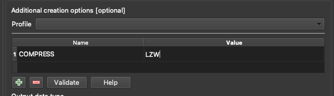
- Advanced Parameters: press + and create a field named COMPRESS and value LZW
The point of this is to compress the file so that it is not too large. LZW compression is the best tradeoff between speed of compression and space savings:
- Set a location to save the file
- Run
Changing the projection using GDAL#
You could use the gdalwarp command line tools:
gdalwarp -s_srs EPSG:3857 -t_srs EPSG:6933 -dstnodata 0.0 -tr 10.0 10.0 -r near -of GTiff -co COMPRESS=LZW sourcefile.tif destinationfile.tif
-s_srs - set source spatial reference
-t_srs - set target spatial reference
-dstnodata - set the destination nodata value
-tr - set output resolution
-r - set resampling method
-of - set output format
-co - set output creation options (for the compression setting)